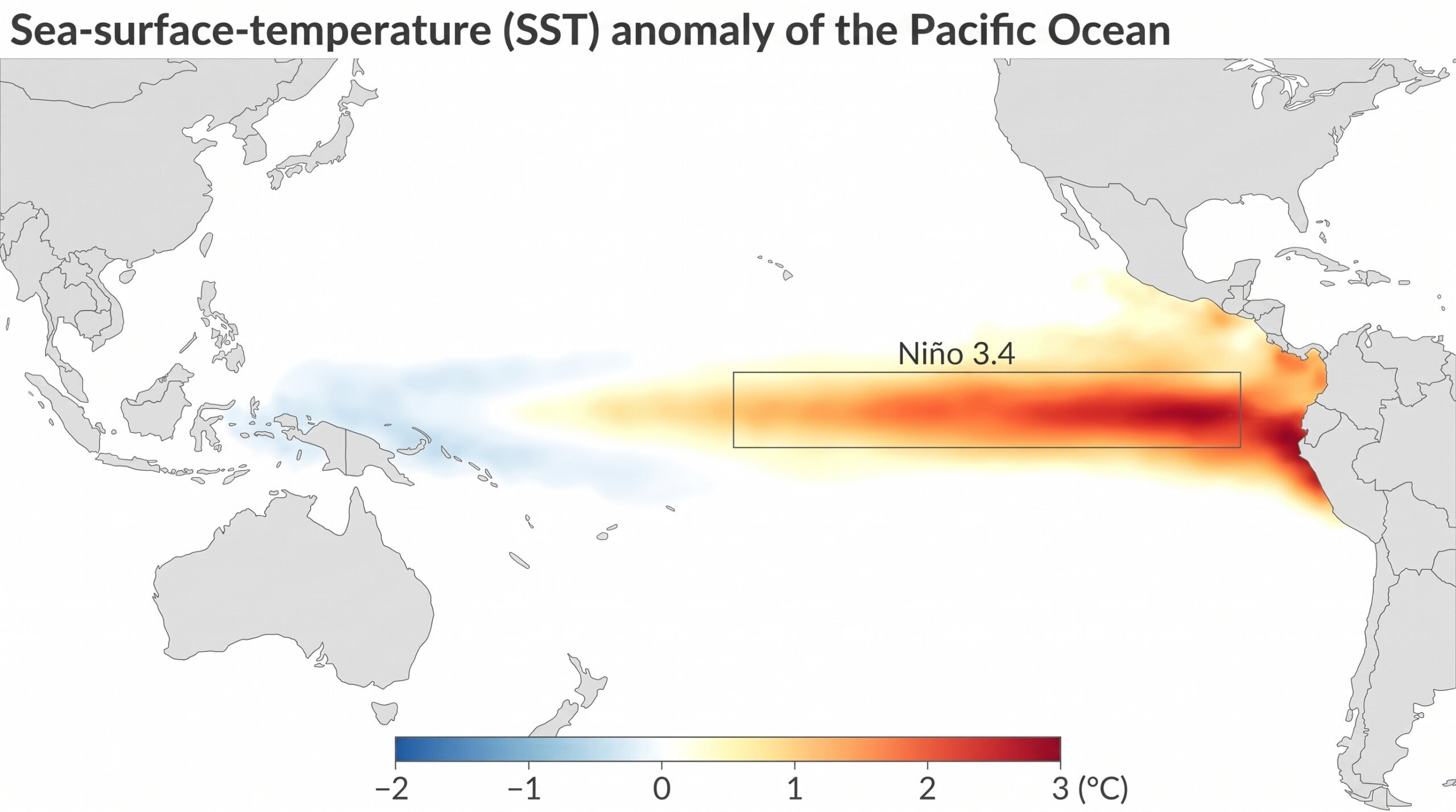
There’s a decent chance this El Niño winter gets talked about for years. As of the National Weather Service’s mid-August update, the El Niño building in the Pacific has a 69% chance of becoming the strongest event on record going back to 1950 — stronger than 1997-98, stronger than 2015-16, the two winters that already reshaped how the Southwest thinks about El Niño. NOAA puts the odds of it reaching “very strong” status at over 90%.
That’s the headline. Here’s the honest version underneath it: a strong El Niño tilts the odds toward a wetter winter here. It does not guarantee one, and the historical record backs that up in some genuinely surprising ways. So before you start planning a season around a wet Mojave, it’s worth understanding what this forecast actually says, what similar winters have actually done here before, and what it means for how you plan trips between now and spring.
What’s Actually Happening in the Pacific
El Niño is a warming of the surface waters in the central and eastern tropical Pacific, and it’s currently running hot. NOAA’s Niño-3.4 index — the standard measure — sat at 2.7°C above average in mid-August, comfortably past the 2.0°C line that separates a “strong” event from a merely “very strong” one. That’s not a marginal reading. It’s in the territory of the two El Niño winters most Southwest residents already have some memory of.
What that number means for us specifically is where things get less certain, and NOAA is upfront about it — even at this strength, “impacts are not guaranteed.”
What NOAA’s Outlook Actually Says for This Region
The Climate Prediction Center’s seasonal outlook has probabilities of above-normal precipitation increased to above 50% across much of coastal California and southern Arizona, running from December through the following spring. That’s a real signal, not a coin flip.
Temperature is murkier. El Niño winters typically suppress the odds of above-normal temperatures across the southern tier — one of the more counterintuitive parts of the pattern — even as much of the country trends warmer.
NOAA also flags a specific historical detail worth remembering going in: recent strong El Niño events have tended to deliver their heaviest precipitation late in the season, with February 1998 and February 2024 both ranking among the wettest Februaries on record for parts of the region. If this one follows that pattern, don’t expect it to show up all at once in December.
What Strong El Niño Winters Have Actually Done Here Before
This is the part worth sitting with, because it cuts against the “here comes a soaked winter” instinct.

1997-98 — the benchmark strong El Niño — did deliver, in a sense: Nevada recorded its second-wettest February since record-keeping began in 1895. But statewide, that winter didn’t even crack the top third of seasons for total precipitation across the broader Southwest region. And in coastal California, where the rain genuinely was historic, the damage came in lower than you’d expect for a record wet season — because the rain arrived spread across nearly double the normal number of rainy days, instead of stacking up in a handful of violent storms. Total rainfall mattered less than how it was paced.
2015-16 — comparable strength to what’s forecast this year — is the more sobering data point for anyone in Southern Nevada. That fall, Las Vegas logged just 1.42 inches of rain, good for only the 22nd wettest fall on record. A textbook-strength El Niño, and the payoff locally was underwhelming.
2023-24 — a moderate El Niño, weaker than what’s forecast now — actually delivered more visibly on the ground here: Lee Canyon picked up 215 inches of snow against a 129-inch normal, and Las Vegas saw its 16th-wettest fall.
Put together, that’s not a pattern of “strong El Niño = wet Mojave winter.” It’s closer to: El Niño loads the dice, but the Mojave corridor sits far enough from the coast, and gets influenced by enough other regional factors, that a strong event is no guarantee of a wet one on the ground here. Dan McEvoy at the Desert Research Institute put it plainly when asked about this winter — there are still real unknowns in both precipitation and temperature, even with a forecast this strong.
What This Actually Means for Trip Planning
Treat the odds as real but not a promise, and plan accordingly.

Wash and slot canyon awareness goes up, not down. Even an average-precipitation winter can produce a flash flood in the wrong wash at the wrong time — see the site selection guidance in Why I Camp Alone in the Mojave and the flood-risk designation notes in BLM Land Access Rules. A season with elevated odds of above-normal precipitation is a season to take that more seriously, not less — especially if the historical pattern holds and the heaviest rain lands late-season, in February, when people are less on guard for it.
Unpaved BLM and forest roads can wash out with surprisingly little rain. If a route depends on a dry wash crossing or a graded dirt road holding its surface, build in a Plan B before you’re out there discovering it’s gone.
A wetter winter, if it materializes, is genuinely good news for camping — cooler temperatures, less dust, and a real shot at a wildflower bloom if enough rain lands at the right time. Pair that with the region-by-region timing notes in Best Seasons for Different Mojave Regions, and it’s worth planning for both outcomes rather than betting the season on one.
Don’t build your whole trip calendar around an August forecast. NOAA updates its seasonal outlook monthly, and the real test — per the 1997-98 and 2023-24 pattern — may not show up until deep in winter. Check the current outlook before locking in a February trip specifically banking on rain.
Bottom Line
This is shaping up to be one of the strongest El Niño events on record, and that genuinely does tilt the odds toward a wetter winter across the Mojave corridor. But “tilts the odds” is doing real work in that sentence — the last time a comparably strong El Niño hit, Las Vegas had one of its driest recent falls. Plan for the possibility of a wet, cooler winter. Don’t plan around it as a certainty. And if you’re out in washes or on unpaved roads between now and spring, treat this as the season to be more careful about it, not less.
