The Mojave Desert is a hot, high, dry desert covering southeastern California, southern Nevada, the northwest corner of Arizona, and a small sliver of southwest Utah. It’s the smallest and driest of North America’s major deserts, and it holds both the lowest point on the continent and the Joshua tree, the plant that says you’re in the Mojave more than any other. Most of it sits between roughly 2,000 and 5,000 feet, which is why people call it a “high desert.” Everything below is detail on those few sentences.
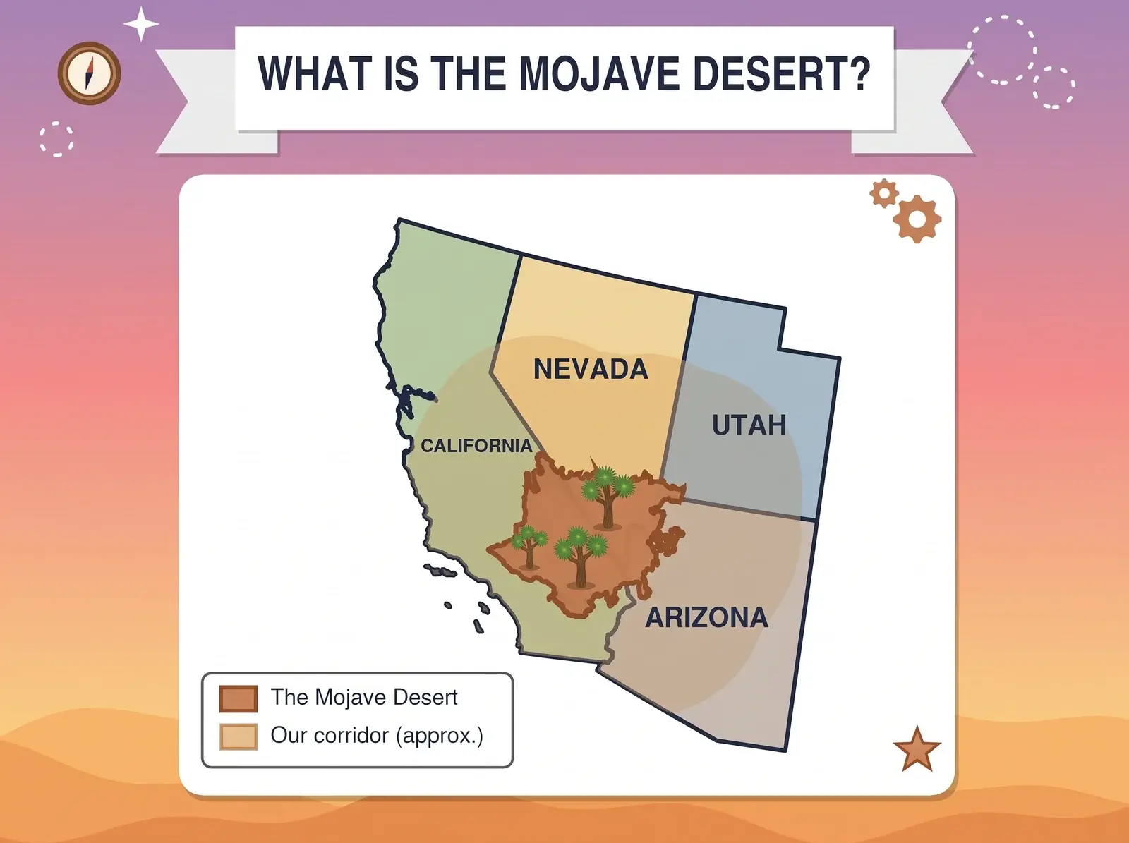
Where the Mojave Sits, and Where It Stops
Nobody agrees on the exact edges, and the published size shows it. The EPA’s ecoregion map puts the Mojave Basin and Range at roughly 49,000 square miles, while other definitions run from about 31,000 to 54,000. Most of it is in California and Nevada. By the EPA’s outline, only about 6,000 square miles reach into Arizona, and a sliver of roughly 700 reaches into Utah.
Some edges are clearer than others. On the west, the San Andreas and Garlock faults and the mountain ranges beside them, the Transverse Ranges and the southern Sierra Nevada, form a hard wall that also blocks most Pacific moisture. To the north, the Mojave gives way to the cooler Great Basin. To the south and east it blends into the Sonoran Desert. In the far northeast corner, around St. George, Utah, three landscapes overlap: Mojave, Great Basin, and Colorado Plateau. The eastern edge is the fuzziest of all, with no single indicator species to mark it, so where the Mojave ends depends on which scientist you ask.
How You Can Tell You’ve Crossed a Line
The edges are drawn by plants. The Joshua tree is the Mojave’s signature, and creosote bush and white bursage cover most of the desert floor. Head south and east and the vegetation starts changing as saguaros and other Sonoran species show up. Head north and creosote gives way to sagebrush, which is Great Basin country. Joshua trees do turn up outside the Mojave (the National Park Service notes them growing alongside saguaros in western Arizona and among pines in the San Bernardino Mountains), so treat one as a strong hint, not a border.
Temperature is the other big difference. The Mojave counts as a hot desert, like the Sonoran and Chihuahuan. The Great Basin is a cold desert, cooler and dominated by plants that aren’t subtropical in origin.
From Below Sea Level to Over 11,000 Feet
The vertical range is enormous. Badwater Basin in Death Valley sits 282 feet below sea level, the lowest point in North America, while Telescope Peak in the Panamint Range reaches 11,049 feet. That’s more than two miles of relief you can see in one view.
Rain is scarce. The Sierra Nevada and Transverse Ranges catch most Pacific moisture, a rain shadow effect, so the low valleys often get only a few inches a year, mostly from winter storms between November and April. Summers are brutal: Death Valley hit 134°F on July 10, 1913, at Greenland Ranch (today’s Furnace Creek), and the World Meteorological Organization certified it in 2012 as the highest air temperature ever recorded on Earth.
Pack for the Cold, Not Just the Heat
Our Best Seasons for Different Mojave Regions guide breaks down when to go where, and the El Niño winter piece covers what a wet year can change.
What Actually Lives Here
Beyond the Joshua tree and creosote, the desert’s characteristic plants include Mojave yucca and Utah agave, plus a spring wildflower show in wet years. The animals are the ones you’d hope to see and a few you’d rather not surprise: desert tortoise, bighorn sheep, coyote, black-tailed jackrabbit, the Mojave ground squirrel (found nowhere else), and the Mojave green rattlesnake. Our Mojave Desert Wildlife Guide covers what you’re actually likely to see on a trip.
The Desert Versus the Corridor We Cover
Most of what we write about is the Mojave itself. But we don’t stop at the ecological line. The region around it has too many good places to leave out: canyon country in Utah, high desert in Arizona, the Great Basin ranges of central Nevada, and Colorado Plateau country that isn’t Mojave at all. Moab, for instance, is a different desert entirely, and we’re still going to write about it.
So think of it in two layers. The Mojave Desert is the core, the place this site is named for and built around. The corridor is the wider stretch across California, Nevada, Arizona, and Utah that we cover because it’s connected by roads, public land, and the kind of trips people take out here. When a piece is about the desert proper, we’ll say so. When it reaches beyond, we’ll say that too.
Where to Go From Here
If you’re planning a trip, start with the rest of our Explore section: National Parks & Preserves, State Parks, and BLM & Public Lands. For the desert itself, see our Dark Sky and Stargazing guide and BLM Land Access Rules.
Figures on this page come from the EPA ecoregion mapping, the National Park Service, and NOAA’s National Centers for Environmental Information. Desert boundaries vary by source, so treat sizes as approximate.